Words by Karlie Brady

-----------------

A trip to the tip of Cape York Peninsula is a bucket list item for many an adventurous traveller. Karlie Brady makes the four wheel drive pilgrimage to the most Northerly point of Australia.

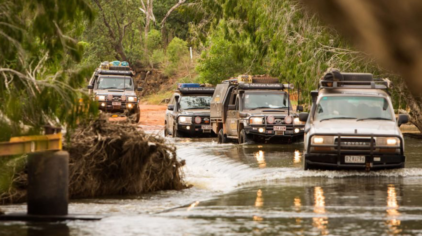
My whole-body rattles as we drive the corrugated dirt road, dodging potholes and bumps in the road, that if you aren’t quick enough to avoid, send the whole car flying off the ground. We follow the dusty track for what feels like forever, driving further and further into the wilderness.

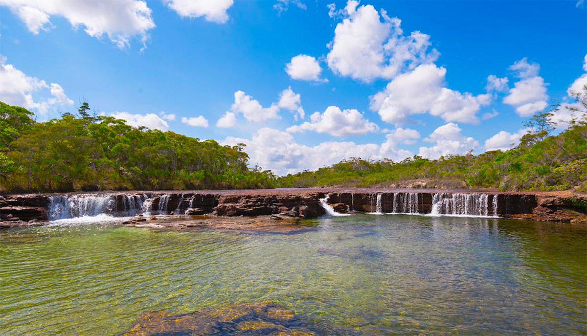
You’d be forgiven for thinking the outback of the Queensland peninsula is nothing but a hot dustbowl filled with human-sized termite mounds and dead grass. However, while it certainly has its fair share of red dirt, mounds and sunburnt plants, it is also full of many hidden treasures just off the beaten track.

Cape York Peninsula, North Queensland, the tip of Australia, is where I found myself this past September, on the trip of a lifetime. This picturesque, largely undeveloped wilderness showcases some of the best natural attractions Queensland has to offer, from the typical iconic Australia outback countryside and hidden crystal-clear waterfalls and swimming holes to untouched beaches and rainforest.

My journey began a little further down the coast in Port Douglas, where myself, my partner and a few friends set off in a three-car convoy headed north up along the Peninsula Developmental Road where you just keep going up and up and up.

An entire day driving is what you’ll face next with the only pit stops being the roadhouses along the way. Each boasts their own famous burger, fuel, and accommodation if you need a break.

Our first stop is Bramwell station roadhouse where we fuel up amongst the cattle that roam the car park. This stop also marks the start of the Old Telegraph Track.

If you thought the track before was bumpy it’s nothing compared to the crazy Telegraph Track which is a four-wheel-drive enthusiast’s dream. The track follows the original telegraph line that ran from Cooktown to Bamaga from 1885 to 1987 and many of the old telegraph poles can still be seen as you pass by.


It’s a rough road with many twists and turns, deep sand patches and river crossings. For that reason, it’s only accessible during the dry season, usually from May through to October, but check conditions before you set off.

It’s extremely important should you tackle the Telegraph Track that you prepare your vehicle. It must be a large four-wheel-drive able to cross water and you should also be prepared for some damage, as the road is full of deep rivets and a lot of corrugation.

Cape York local, Ben Fletcher, told us it was important to get out of the car and walk each crossing before driving through as you never know what’s hidden below the water.

“I’ve seen a lot of cars written off because people are too lazy to get out and check,” Ben warned.

Now you don’t have to do the Telegraph Track to get to the tip as any car could use the main Bamaga Road, but you would really miss the experience of the trip to the tip and you’ll skip all the best parts hidden off small goat tracks along the way. However, there are bypass tracks that allow you to get to some of the best parts along the Telegraph Track without hitting the most treacherous sections.

Along the Telegraph Track, there are numerous spots to camp, usually close to a river. Our first camp was at the Dulhunty River in a small site just off the main path right along the river bank. It’s in the middle of the bush and we had the place to ourselves so we set up camp for a couple of days. With a shallow creek metres from our camp, it was the perfect spot to spend the day in the water with some food and beverages. It’s also great to have some fresh water when your camping to top up your water supply and it also doubled as our shower.

Not far from the Dulhunty is the infamous Gunshot Creek crossing which is at the top of the bucket list for many four-wheel-drivers. The almost vertical muddy drop was a bit too much for us but there is a small bypass around the crossing that might just save the life of your vehicle.

Continuing along we soon re-join the main Bamaga Road marking the end of the southern half of the Old Telegraph Track. Another 10 or so kilometres up the road, a detour on a side track brings you to the ultimate gem of the Cape, Fruit Bat Falls. The huge natural crystal-clear pool and waterfall is a must-see stop. And while there is no camping here it is a great spot for a picnic and a cool off.

Back on the main Bamaga road, we continue north until we hit the Jardine River Ferry, the only way to cross the large croc-infested river. There is a fee to cross the ferry, which you pay on the south side, but it also covers camping access in the national park.

Further north, our next camping destination was at a place along the mouth of the Jardine River called Mutee Heads. Right along the beach are multiple spots to camp, although regrettably we followed the track too close to the beach and all three cars got bogged, which took a lot of time and effort to get out of, so watch where you drive. But finally, we set up camp overlooking the beautiful beach and sunset over the east coast of the peninsula.

“Fruit Bat Falls, the huge natural crystal- clear pool and waterfall is a must-see stop. And while there is no camping here it is a great spot for a picnic and a cool off.”

After days without fresh water at Mutee Heads, we were all pretty dirty and craving a hot shower and a bit of civilisation. A great spot for this is Cape York Camping Punsand Bay, just a little further up the road. This is the northernmost campground in Australia and boasts flushing toilets, hot showers and a bar, which after a week in the wilderness was most welcome.

The campground, cabins and restaurant overlook the white sandy beach and aqua waters of the Torres Strait Islands. The wood-fired pizzas from the restaurant here are also another must-do on your trip.

From Punsand Bay it’s just a short drive to the main attraction of the trip, “the tip.” From dirt and dust, the last few kilometres up to the tip is actually rainforest, which is odd after all the red dirt all the way up.

“After taking the ever-important photo with the sign, we noticed the abundance of oysters on the rocks, most had already been cracked and eaten, but we managed to smash open a few and enjoyed a couple of drinks and oysters on the tip of Australia.”

Once you arrive at the end of the road, the last hurdle in your journey to the tip is a trek over the rocky bluff, then it’s down to the famous sign declaring you at the most northern point of the Australian continent. That’s when you’ve finally made it! After taking the ever-important photo with the sign, we noticed the abundance of oysters on the rocks, most had already been cracked and eaten, but we managed to smash open a few and enjoyed a couple of drinks and oysters on the tip of Australia.

After reaching the tip we of course, had to turn around and start the long trip home, however that was not the end of our adventures. South of the Jardine River Ferry, we re-joined the Old Telegraph Track via a bypass which brought us onto the track near Sam’s Creek, where we once again set up camp for a few days.

This was by far my favourite place on the trip, but most people would pass by without seeing its true beauty. A rugged-looking creek crossing is what you can see from your car as you pass through it. While that sight is pretty, its similar to many other crossings along the way. But thanks to a little bit of local knowledge we followed a small bush track through the scrub until we found what is known as the Hidden Waterfall. The secluded swimming pool under a small waterfall has crystal clear water and high walls providing plenty of shade. The thigh-high water was perfect to sit in with a few drinks and the falls provided a natural shower.

From our camp at Sam’s Creek, we used quad bikes to venture to other crossings along the track, including Mistake Creek, Cannibal Creek and Nolan’s Brook. Each just as pretty as the next but take serious four-wheel-drive action to cross in cars.

We also took a day trip from our camp to visit Elliot and twin Falls. More beautiful waterfalls and natural pools that you could just spend days in relaxing and soaking up the sun.

Sam’s Creek was the last spot on our two-week trip and I would recommend taking that long to ensure you see everything. A 10-hour trek home, but it was well worth it to discover the hidden treasures amongst the rough outback of Cape York Peninsula.